
Even though Texas winter can mean 70 degrees and sunny, many of our scientists are bundling up to do their work. With cold weather as their backdrop, they travel the world to explore the poles or study patterns of ice and snow.
Here is a roundup of “cool” UT research in time for the chilliest season.
Observing Stars Through Winter
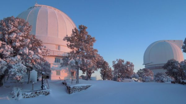
Yes, it snows in Texas. Especially in West Texas mountains where the UT McDonald Observatoryis located. As a research unit of the university, it is one of the world’s leading centers for astronomical research, teaching, public education and outreach. Observatory facilities are located atop Mount Locke and Mount Fowlkes in the Davis Mountains, which offer some of the darkest night skies in the continental U.S.
A core part of the observatory’s mission is to advance humanity’s understanding of the universe through research in astronomy and to facilitate graduate and undergraduate education. Even when beautifully blanketed in snow, it is operable and open to visitors. Learn more about its resources and programs offered here.
Traveling to Antarctica in Search of Fossils
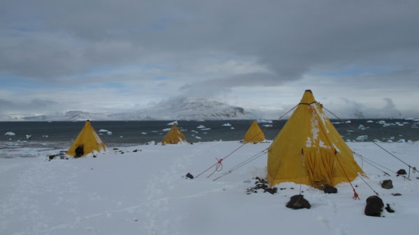
Three years ago, an international team of researchers journeyed to Antarctica to search for evidence that the now-frozen continent may have been the starting point for some important species that roam Earth today. Julia Clarke, a paleontology professor at the UT Jackson School of Geosciences, was a co-lead on the mission.
Before it became one of the coldest places on Earth, Antarctica had a warm, lush jungle climate and a variety of life. As the Age of Dinosaurs ended and the rise of mammals began, about 100 million to 40 million years ago, migration from Antarctica could have played a critical role in the evolution of backboned animals.
Aided by helicopters, scientists conducted research to answer these history of life questions on James Ross Island and other nearby islands off the tip of the Antarctic Peninsula. This area is one of the few spots in Antarctica where fossil-bearing rocks are accessible.
The monthlong expedition was part of the Antarctic Peninsula Paleontology Project, or AP3, a research initiative funded by the National Science Foundation.
Discovering How Snow Data Affects Temperature Predictions
In 2016, UT scientists discovered that incorporating snow data collected from space into computer climate models significantly improves seasonal temperature predictions.
Snow influences the amount of heat that is absorbed by the ground and the amount of water available for evaporation into the atmosphere, which plays an important role in influencing regional climate. These findings were the first to go beyond general associations and break down how much snow can affect the temperature of a region months in the future. Improving temperature predictions is a key element to improving the computer models that provide climate predictions months in advance.
The findings, published in Geophysical Research Letters, could help farmers, water providers, power companies and others who use seasonal climate predictions to make decisions.
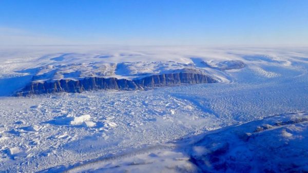
Mapping Movement of Greenland Glaciers
A team of scientists, including UT geophysicists, created the first map that showed how the Greenland Ice Sheet moved over time.
The map revealed that ice in the interior moved more slowly toward the edges than it had, on average, during the past 9,000 years.
The findings, published in 2015 in Science, found that along Greenland’s periphery, many glaciers are rapidly thinning. However, the vast interior of Greenland is slowly thickening.
“Scientists are very interested in understanding how ice sheets flow and how that flow may have been different in the past. Our paleo-velocity map for Greenland allows us to assess the flow of the ice sheet right now in the context of the last several thousand years,” said lead author Joe MacGregor, who conducted the work when he was a research associate at UT’s Institute for Geophysics, a research unit of the Jackson School of Geosciences. He is now a researcher at NASA.
Partnering with NASA to Measure Melting Ice Caps
We know ice is melting on the Earth’s poles. But how fast? New data gathered using a green laser in space is helping scientists track the melting ice and giving us a new elevated view of climate change.
NASA’s Ice, Cloud and land Elevation Satellite-2 (ICESat-2), which was launched last year, uses this laser to measure the elevation of the surface of the Earth. The satellite, developed with help from scientists at UT’s Applied Research Laboratories, tracks changes in the elevation of the planet’s polar ice sheets to within a fraction of an inch.
“This data is really helping us understand what is happening on our planet right now,” said Lori Magruder, a senior research scientist at UT and the ICESat-2 science team lead. “The elevation changes that we’re able to measure over the ice sheets can help infer global sea level rise. And those models have been used to refine our ability to predict climate change.”