AUSTIN, Texas — A new study from The University of Texas at Austin is helping scientists piece together the ancient climate of Mars by revealing how much rainfall and snowmelt filled its lake beds and river valleys 3.5 billion to 4 billion years ago.
The study, published in Geology, represents the first time that researchers have quantified the precipitation that must have been present across the planet, and it comes out as the Mars 2020 Perseverance rover is making its way to the red planet to land in one of the lake beds crucial to this new research.
The ancient climate of Mars is something of an enigma to scientists. To geologists, the existence of riverbeds and paleolakes — eons-old lake basins — paints a picture of a planet with significant rainfall or snowmelt. But scientists who specialize in computer climate models of the planet have been unable to reproduce an ancient climate with large amounts of liquid water present for long enough to account for the observed geology.
“This is extremely important because 3.5 to 4 billion years ago Mars was covered with water. It had lots of rain or snowmelt to fill those channels and lakes,” said lead author Gaia Stucky de Quay, a postdoctoral fellow at UT’s Jackson School of Geosciences. “Now it’s completely dry. We’re trying to understand how much water was there and where did it all go.”
Although scientists have found large amounts of frozen water on Mars, no significant amount of liquid water currently exists.
In the study, researchers found that precipitation must have been between 13 and 520 feet (4 to 159 meters) in a single episode to fill the lakes and, in some cases, provide enough water to overflow and breach the lake basins. Although the range is large, it can be used to help understand which climate models are accurate, Stucky de Quay said.
“It’s a huge cognitive dissonance,” she said. “Climate models have trouble accounting for that amount of liquid water at that time. It’s like, liquid water is not possible, but it happened. This is the knowledge gap that our work is trying to fill in.”
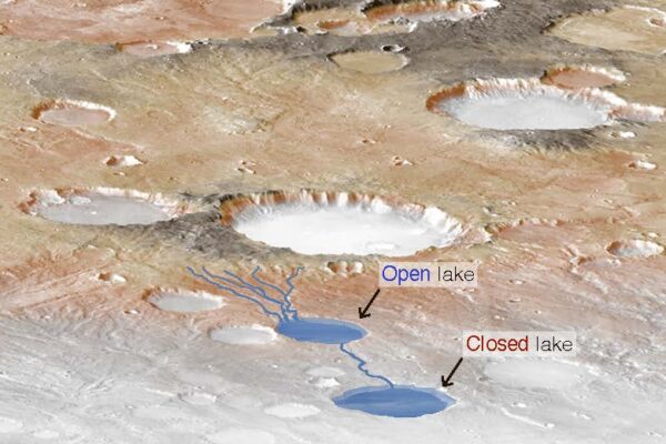
The scientists looked at 96 open-basin and closed-basin lakes and their watersheds, all thought to have formed between 3.5 billion and 4 billion years ago. Open lakes are those that have ruptured by overflowing water; closed ones, on the other hand, are intact. Using satellite images and topography, they measured lake and watershed areas, and lake volumes, and accounted for potential evaporation to figure out how much water was needed to fill the lakes.
By looking at ancient closed and open lakes, and the river valleys that fed them, the team was able to determine a minimum and maximum precipitation. The closed lakes offer a glimpse at the maximum amount of water that could have fallen in a single event without breaching the side of the lake basin. The open lakes show the minimum amount of water required to overtop the lake basin, causing the water to rupture a side and rush out.
In 13 cases, researchers discovered coupled basins — containing one closed and one open basin that were fed by the same river valleys — which offered key evidence of both maximum and minimum precipitation in one single event.
Another great unknown is how long the rainfall or snowmelt episode must have lasted: days, years or thousands of years. That’s the next step of the research, Stucky de Quay said.
As this research is published, NASA recently launched Mars 2020 Perseverance Rover to visit Jezero crater, which contains one of the open lake beds used in the study. Co-author Tim Goudge, an assistant professor in the UT Jackson School Department of Geological Sciences, was the lead scientific advocate for the landing site. He said the data collected by the crater could be significant for determining how much water was on Mars and whether there are signs of past life.
This study was supported by a grant through NASA’s Mars Data Analysis Program.


