AUSTIN, Texas — Earthquakes — like lightning — strike unpredictably. The Earth’s tectonic plates, however, hide subtle warnings that a major fault may soon break. Like forecasting a thunderstorm, knowing how to read the warnings could help communities protect lives, infrastructure and local economies.
For decades, scientists have struggled to reliably give forecasts for major earthquake hotspots, but now, an international team of scientists led by The University of Texas at Austin has embarked on a new initiative to do just that.

“Physics-based forecasting is what we’re trying to achieve,” said project lead Thorsten Becker, a professor at UT’s Jackson School of Geosciences.
The five-year project, funded by the National Science Foundation (NSF), will develop new computing tools, software and instructional material focused on forecast modeling. The team will also train students, hold workshops and recruit new computational geoscientists by drawing on overlooked talent pools and reaching out to underserved communities.
The ultimate goal: computer models that can forecast the chances of an earthquake happening and its likely impact, similar to those used to predict the weather but on longer timescales.
Becker doesn’t expect to see earthquake “weather” forecasts within five years, but he believes the idea is now technically possible. The bulk of what remains is figuring out the physics governing earthquakes and their inherent uncertainties: key ingredients in the forecasting process.
The UT scientists will team up with researchers at universities and national labs working on three of the world’s earthquake hotspots: the U.S. Pacific Northwest, New Zealand and Japan. The sites selected are all subduction zones — places where tectonic plates meet. The differences between them will allow researchers to test their models and figure out what conditions to look for when deciding whether an earthquake is likely.
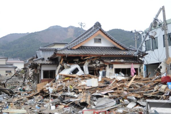
Subduction zones are important because they are the sites of the world’s most powerful earthquakes and can trigger dangerous tsunamis, such as the one following the 2004 Indian Ocean earthquake that killed almost a quarter of a million people in 14 countries.
They are a challenge to study, however, because they are usually situated offshore and driven by deep geologic forces that take hundreds to millions of years to unfold, at scales from fractions of an inch to thousands of miles. That’s why earthquake scientists turn to computers to simulate faults and their tectonic settings. The new project will look for gaps in the physics and figure out what needs to be measured to make the simulations more useful to forecasters.

“It’s a little bit like calculating the probability of a pandemic,” said Laura Wallace, a research scientist at the University of Texas Institute for Geophysics, who is based in New Zealand. “You can’t know when and where the next one will happen, but you can look at factors that make it more likely and model how it might unfold.”
Becker and Wallace are joined on the project by co-leaders Alice Gabriel, an earthquake physicist at the Scripps Institution of Oceanography and LMU Munich, Germany, and Dana Thomas, a Jackson School outreach coordinator who will help recruit a new generation of computational geoscientists. The project includes scientists at the Jackson School, its Institute for Geophysics, UT’s Oden Institute for Computational Engineering and Sciences, and supercomputers at the Texas Advanced Computing Center.
Collaborating institutions on the $2.8 million project are UT Austin, the University of California at San Diego, Indiana University, the Massachusetts Institute of Technology, ETH Zürich, Utrecht University, the Japan Agency for Marine-Earth Science and Technology, the Earthquake Research Institute at the University of Tokyo, NIED, and New Zealand’s GNS Science.